About Us
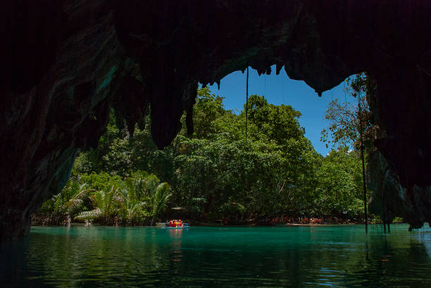
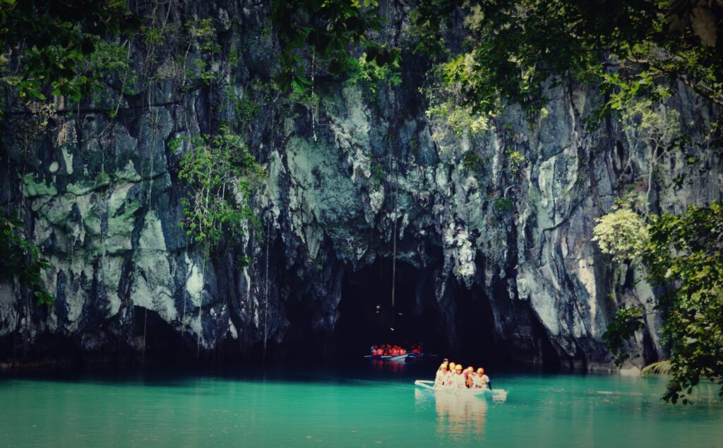
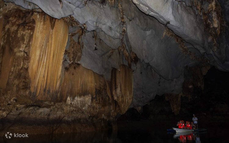
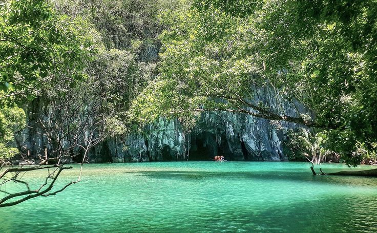
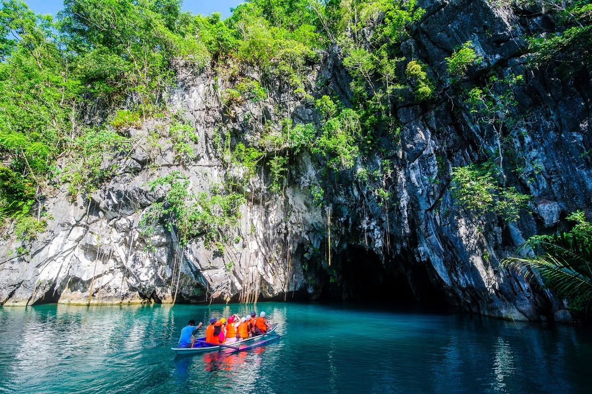
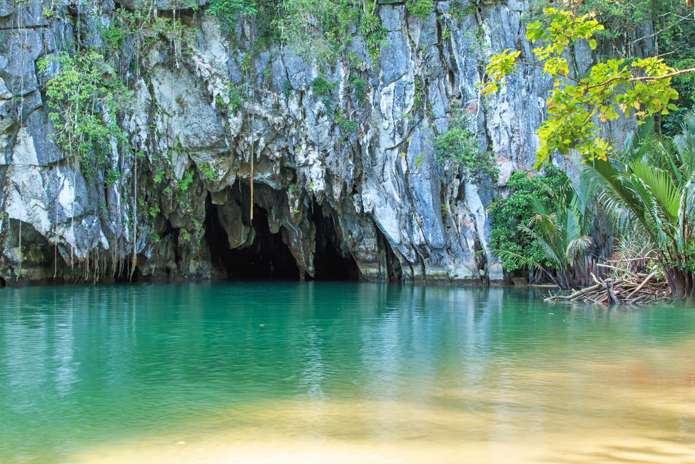
“The Puerto Princesa Underground River in Palawan, Philippines, is a stunning natural wonder where a river flows beneath towering limestone mountains, adorned with impressive stalactites and stalagmites. A UNESCO World Heritage Site, it offers visitors a unique adventure through its mysterious caverns and rich biodiversity, surrounded by lush tropical forests.”
Legal Basis
The management and protection of the Puerto Princesa Subterranean River National Park (PPSRNP) are anchored on several national laws that ensure the conservation of its unique natural and ecological value. Foremost among these is Republic Act No. 7586, also known as the National Integrated Protected Areas System (NIPAS) Act of 1992, which provides the legal framework for the establishment, management, and protection of designated protected areas in the Philippines, including PPSRNP.
In addition, the park is governed by Republic Act No. 7611, or the Strategic Environmental Plan (SEP) for Palawan Act of 1992, which promotes sustainable development while safeguarding Palawan’s environmentally critical areas. The management of PPSRNP is further supported by Republic Act No. 7160, or the Local Government Code of the Philippines, which empowers local government units, particularly the City Government of Puerto Princesa, to actively participate in environmental governance, conservation, and enforcement of policies within their jurisdiction.
History
The Park was established on March 26, 1971, by virtue of Proclamation No. 835 issued by the late President Ferdinand E. Marcos. Formerly known as the St. Paul Subterranean National Park, it comprised of 3,901 hectares of terrestrial reservation. Experts later concluded that the size of the Park was inadequate to protect the water shed of the Underground River and the significant biodiversity present. To ensure long-term viability, Proclamation No. 212 was signed by President Joseph E. Estrada on November 16, 1999 expanding its area to 22,202 hectares that now includes the entire catchment for the Underground River and the forest ecosystems important for biodiversity conservation. It was also renamed to Puerto Princesa Subterranean River National Park to properly identifying it with the place.
The PPUR officially represented the Philippines in the global search for the New 7 Wonders of Nature. Pres. Benigno S. Aquino signed proclamation No. 182 on June 3, 2011 declaring a national and international campaign for the PPUR. This united Filipinos here and abroad who solidly supported the campaign and voted for inclusion of the Philippines to ssuch a prestigious list. The PPUR was declared as one of the New 7 Wonders of Nature on November 11, 2011.
Read More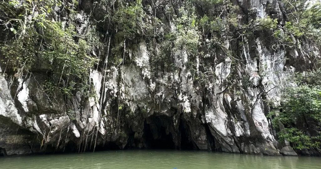
World Heritage Inscription
The Puerto Princesa Subterranean River National Park (PPSRNP) was officially inscribed on the United Nations Educational, Scientific and Cultural Organization (UNESCO) List of Natural World Heritage Sites on December 4, 1999, in recognition of its outstanding universal value to humanity. This prestigious designation highlights the park’s exceptional natural features and its global importance in environmental conservation.
The site was inscribed under Criterion (vii), which recognizes areas that contain superlative natural phenomena or exhibit exceptional natural beauty and aesthetic importance. The dramatic limestone karst landscape, pristine forest cover, and the world-renowned underground river system flowing directly into the sea exemplify these qualities. Additionally, PPSRNP meets Criterion (x), as it contains some of the most important and significant natural habitats for the in-situ conservation of biological diversity. The park supports a wide range of flora and fauna, including endemic and threatened species, making it a vital refuge for biodiversity and ecological processes.
This UNESCO recognition underscores the international commitment to protect the Puerto Princesa Subterranean River National Park and reinforces its role as a model for sustainable conservation and responsible ecotourism in the Philippines and beyond.
National Geological Monument
The Puerto Princesa Subterranean River National Park (PPSRNP) was officially declared a National Geological Monument on December 4, 2003 by the National Committee on Geological Sciences (NCGS). This recognition was conferred in acknowledgment of the park’s outstanding scientific importance, particularly its value as a permanent natural laboratory for the study of geological processes.
The park’s extensive limestone karst formations, cave systems, and subterranean river provide exceptional opportunities for research on speleology, geomorphology, hydrology, and other earth science disciplines. Its geological features are considered unique and of high scientific value, offering insights into the evolution of karst landscapes and natural processes over millions of years. The declaration further emphasizes the need to protect and preserve PPSRNP, not only for its ecological and aesthetic significance but also for its continuing contribution to scientific knowledge and education.
Physical Features
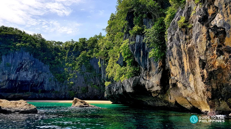
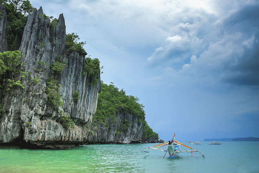
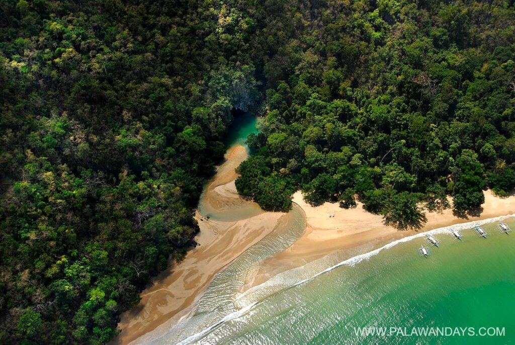
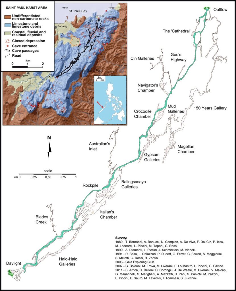
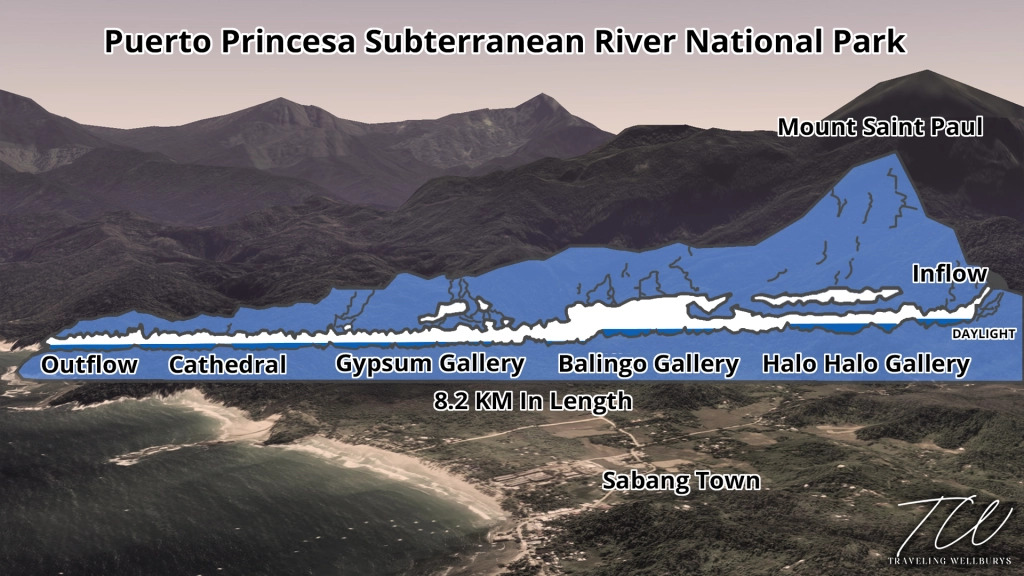
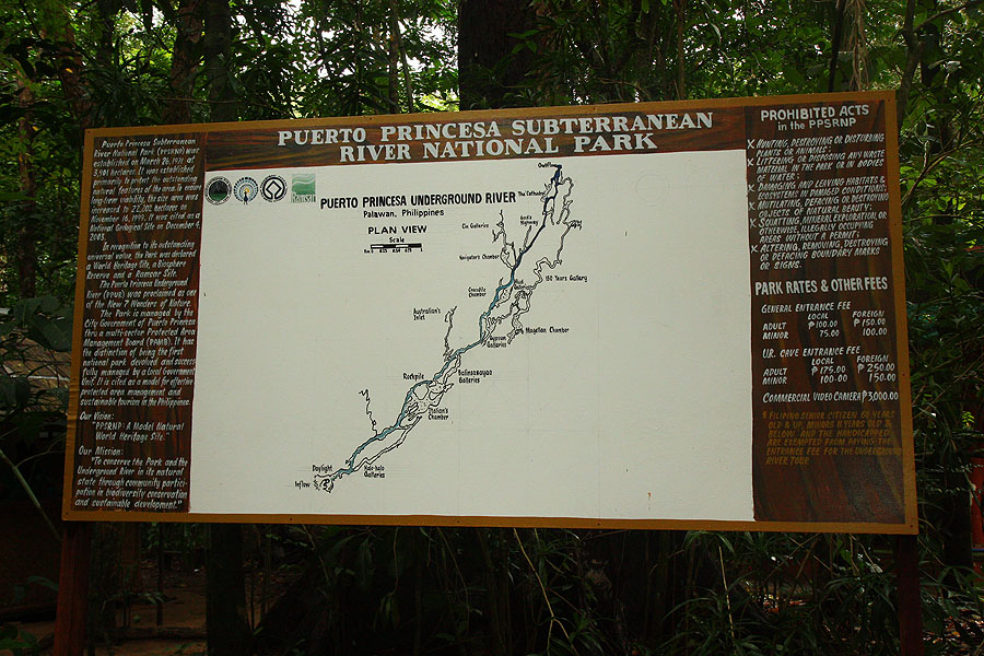
The topography of the Puerto Princesa Subterranean River National Park is highly diverse, ranging from flat lowland terrain to rolling hinterlands, and from forested hills to rugged mountain peaks. Dominating the landscape are three major peaks: Cleopatra’s Needle, the highest at approximately 1,500 meters, Mount St. Paul at 1,028 meters, and Mount Bloomfield at 870 meters. These peaks form part of the extensive limestone or karst outcrop known as the St. Paul Mountain Range, a prominent geological feature within the park.
The St. Paul karst formation stretches for about 11 kilometers, with an average width of 3 to 5 kilometers, covering an estimated area of 35 square kilometers. Geological studies suggest that this limestone formation dates back approximately 16 to 20 million years, making it a significant record of the region’s geological history. Its rugged cliffs, caves, and sinkholes are characteristic of mature karst landscapes shaped by millions of years of natural erosion and water flow.
The park also plays a crucial role as a watershed and catchment area for two major river systems. The Cabayugan River originates from the slopes of Mount Bloomfield, flowing through agricultural lands where it irrigates paddy farms before disappearing beneath Mount St. Paul, where it forms the famous underground river. The Babuyan River, stretching approximately 54 kilometers, is the longest river in Palawan and serves as a vital source of water for surrounding communities. It supports domestic needs and agricultural activities, highlighting the park’s importance not only as a natural wonder but also as a lifeline for local livelihoods.
Climate
Seasons
Wet season from June to December; dry and hot the rest of the year.

Average Temperature
29°C on average, creating warm tropical conditions year-round.
Annual Rainfall
Approximately 1,148 mm per year, supporting lush vegetation.
Relative Humidity
High humidity around 85%, typical of tropical environments.
Sunlight
Bright tropical sun most of the year, especially during dry season months.
Catchment Properties
The Puerto Princesa Subterranean River National Park serves as a crucial catchment area for two of Palawan’s most important rivers. The Cabayugan River begins on the slopes of Mount Bloomfield, meandering through picturesque paddy fields where it naturally irrigates the farmland. Eventually, the river disappears beneath Mount St. Paul, resurfacing as the world-famous underground river, a key feature that highlights the park’s unique geological and ecological significance.
The Babuyan River, on the other hand, stretches approximately 53 kilometers, making it the longest river on the island. Both rivers are essential not only for the natural environment but also for the surrounding communities, supplying water for domestic use and agriculture, while supporting the park’s rich biodiversity and maintaining ecological balance.
Biodiversity

The Site contains a full mountain to sea ecosystem and protects some of the most significant forest area within Palawan Biogeographic Province. Eight forest formations are present: forest over limestone soils, they are composed of species that have adapted to very thin soil such as the Queensland umbrella tree (schefflera) and begonia; montane forest, of Cleopatra Needle (800-1,500 masl) east of the Park, vegetation is characterized by the growth of mosses, lichens and ferns; forest over ultramafic soil were vegetation is composed mostly of shrubs and trees growing to a height of not more than 1.5 meters infested with a scrambling bamboo species (Schizostachyum diffusum); lowland evergreen forest include species such as the Dracontomelon dao and Intia bijuga; riverine forest that include species such as the Homonoia riparia ; freshwater swamp forest are composed of tree species adapted to being partly submerged in water for part or most of the year; beach forest include Calophyllum inophyllum, Pongamia pinnata, and Pandamus sp; and mangrove forest along the Sabang river. Species identified belonged to the Rhizophoraceae family such as Rhizophora spp. and Bruguiera spp.
Read MoreLand Use
Land use within the Puerto Princesa Subterranean River National Park (PPSRNP) is diverse, reflecting both its ecological significance and human activity. The park is primarily composed of primary and secondary forests, which together cover more than half of its total area and are strictly designated for conservation purposes to protect the unique biodiversity and ecological processes of the region. Brushlands and grasslands occupy transitional areas between the dense forest and human-modified landscapes, providing important habitats for various wildlife species.
Human activity within the park is largely concentrated around cultivated lands and paddy fields, which are primarily located in and around settlements. These areas are used for growing rice and cultivating fruit trees, supporting local communities’ livelihoods while coexisting with the surrounding natural environment. Built-up areas are mainly found along roadways and coastal zones, reflecting the limited footprint of human infrastructure. Tourist establishments, which form a significant portion of the park’s development, are largely concentrated in Sabang, serving as the gateway for visitors exploring the underground river and surrounding natural attractions. This careful distribution of land use highlights the balance between conservation, community needs, and sustainable tourism within the park.
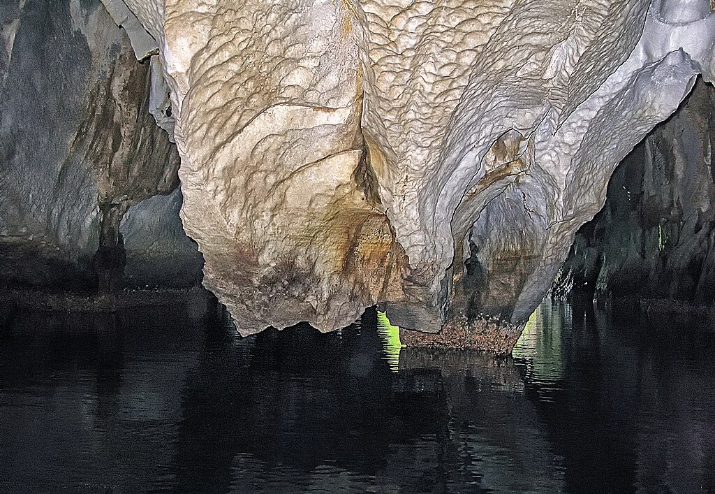
Geology
The limestone or karst formation of the Puerto Princesa Underground River (PPUR) is estimated to be around 20 million years old, making it an exceptional geological record of the region’s ancient natural history. Over millions of years, processes of erosion, weathering, and tectonic activity have shaped this landscape into the dramatic cliffs, rugged terrain, and extensive cave systems that characterize the park today.
Stretching approximately 11 kilometers in length and varying in width from 3 to 5 kilometers, the karst formation covers an estimated 35 square kilometers. Its unique topography includes sharp limestone peaks, deep sinkholes, and intricate cave passages, providing a striking example of a mature karst system and offering scientists a valuable natural laboratory for the study of geological processes.
Beyond its geological structure, the PPUR is also remarkable for its mineral diversity, hosting a total of 11 identified minerals. Among these is the exceptionally rare Serrabrancaite, a manganese phosphate mineral that is formed through the mineralization of guano. The presence of such rare minerals highlights the intricate connections between the park’s geology and the biological processes that occur within it.
These geological and mineralogical features, combined with the ancient karst landscape, make the PPUR not only a site of stunning natural beauty but also an important area for scientific research and education. Its unique formation continues to attract geologists, ecologists, and nature enthusiasts alike, reinforcing the park’s significance as a natural wonder worthy of preservation and study.
People and Livelihood
The surrounding areas are ancestral domains of the Batak and Tagbanua, two of the seven cultural groups of Palawan. Two CADC’s have been established to protect these indigenous cultural communities. It has a population of 3,829 individuals including around 400 members of the indigenous People. The majority of the population is composed of migrants from other parts of the island as well as from other regions of the Country. Majority of the people speak Pilipino, other dialects spoken include the local dialect Cuyunon, Ilocano and Cebuano. Most household in the PPSRNP earn their living from farming except in Sabang where many household depend on fishing and tourism. Indigenous People are engaged in upland farming and gathering of minor forest products such as rattan poles, almaciga resin, and wild honey as the main source of income. They still resort to hunting game to add to their food requirements.With the international recognitions received by the Park, tourism is now the main economic activity.
Location and Boundaries
The Puerto Princesa Subterranean River National Park (PPSRNP) is situated approximately 360 miles south of Manila, on the midwestern coast of Palawan, one of the Philippines’ most ecologically significant islands. The park lies about 76 kilometers northwest of Puerto Princesa City, making it accessible while still retaining a high degree of natural integrity and isolation from dense urban development.
The park’s present boundaries encompass the entire catchment area of the Underground River, ensuring the protection of the hydrological system that sustains this globally significant natural feature. Adjacent to the park is Barangay Marufinas, which holds important conservation values, particularly for forest protection. The inclusion and protection of these surrounding areas play a vital role in safeguarding the World Heritage values of the site by maintaining ecological connectivity and buffering the core protected area from external pressures.
Geographically, the PPSRNP is located at approximately 10°10′ north latitude and 118°55′ east longitude, placing it within a region known for high biodiversity and unique geological formations. This strategic location contributes to the park’s ecological richness and reinforces its importance as a globally recognized site for conservation and sustainable management.
Topography, Soil and Geology
Topography of the PPSRNP varies from flat terrain to rolling hinterlands, from hills to mountain peaks. The landscape is split at the center by a limestone or karst formation known as the St. Paul limestone. The main peaks are Mt. St. Paul (1,028m), Cleopatra’s Needle (1,500m) at the east and Mt. Bloomfield (870m) on the west. Park is underlain by rock formations consisting of recent alluvium, sandstone and shale. The recent alluvium is made up of transported clay, silt and pebbles.
The limestone or karst formation is estimated to be 20 million years old, is 11 km long, average 4 km in width, and covers an area of around 35 sq. /km, The PPUR host a unusually high number of 11 minerals including the rare mineral “ Serrabrancaite” or manganese phosphate.
Watershed Properties
The Puerto Princesa Subterranean River National Park serves as an important catchment area for two major river systems in Palawan. The Cabayugan River originates from the slopes of Mount Bloomfield, flowing through fertile lowlands where it naturally irrigates paddy farms before disappearing beneath Mount St. Paul, where it transforms into the renowned Underground River. This unique hydrological feature highlights the close relationship between the park’s surface and subterranean water systems.
The park also supports the Babuyan River, which stretches approximately 54 kilometers, making it the longest river in Palawan. Together, these river systems play a crucial role in sustaining local ecosystems and communities by providing water for agriculture, domestic use, and wildlife, while reinforcing the park’s importance in watershed protection and environmental conservation.